This post is part of my portfolio of personal projects resulting from my transition from generalist data science (2013-2025) to geospatial data science, GIS, and GeoAI (2025+).
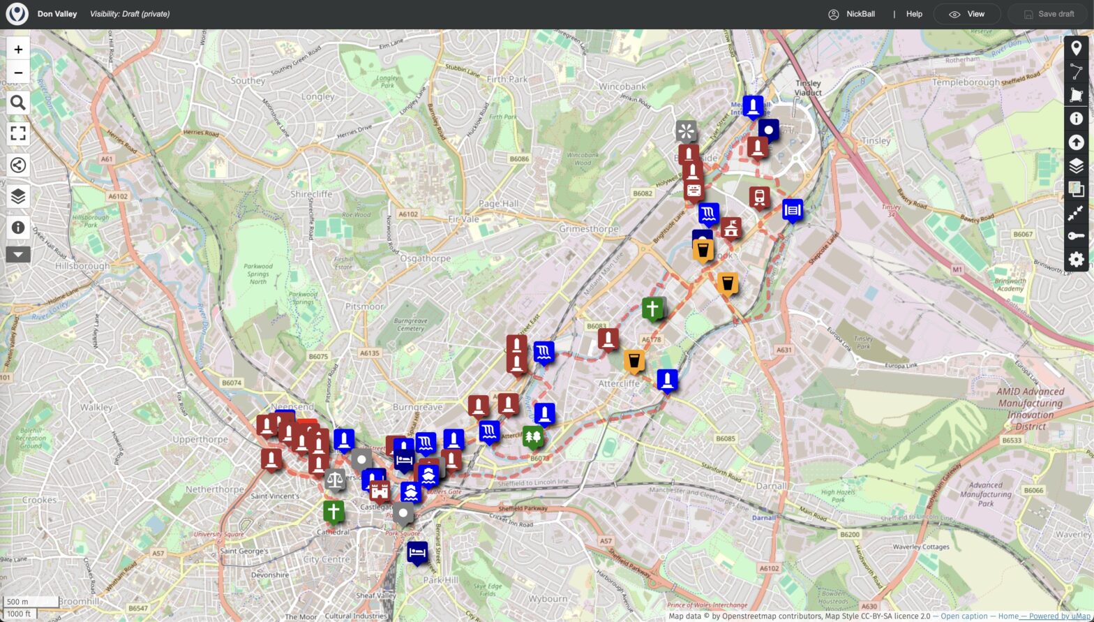
My brother Andrew wrote a walking tour of the historical roots of the modern steel industry, Sheffield’s Don Valley for his blog. The open-source software uMap with an OpenStreetMap base can be used to turn this into a visual tour with a map, walking route, text and photographs. uMap can be used similarly for any piece of writing that involves traveling around an area. The map is available here .

Don Valley
Extending northeast from Sheffield City Centre, Don Valley is an area of global historic importance because of the history of the Sheffield steel industry. This encompasses its origins, the invention of stainless steel, and the manufacture of many products, the most well-known of which is cutlery.
Why map it?
Sheffield is a large modern city that has moved on since these industrial days, and so viewing such history in-place today requires knowing where to look, and what you are looking at. What you need, in other words, is a guide, and Andrew’s walking tour provides this.
The original tour is a text document that is nice to read and well researched. It is, however, only text, and so unless you know Sheffield very well already, or walk the tour in-person, there is a certain amount of abstraction to the history described.
For this reason it benefits from adding a map:
- Visualize the locations
- Show the walking route
- Incorporate text into the map
- Add pictures
Furthermore, the approach taken is generic: any text that involves describing places could be mapped in the same way.
uMap
uMap provides an open source solution that allows geospatial locations (points, lines, and polygons) to be overlaid on a street map base. It is built on top of the widely used Leaflet mapping software.
uMap is generally used in a no-code fashion, although GIS knowledge, use of markup, etc., is useful for more advanced features.
Making the map
We start by selecting the basemap, OpenStreetMap in English, and an appropriate center and zoom level. The center is the start of the walk at Sheffield Cathedral, and the zoom is to Don Valley.
Then we use the points datatype to add the locations mentioned in the text, formatting with various properties such as name, icon type, color, etc.

The walking route is added using the line datatype, following paths where they are marked, and placed in the road center where they are not. Sidewalks are not generally marked on the basemap used, likely because its maximum zoom level is not as high as the original OSM. The linestring resulting also has nodes in some places with more than two lines intersecting, because the route loops and returns to places already passed.

We did not use the polygon datatype on the current map. It could be added, for example to show the outlines of buildings of interest, but there was sufficient content already for our purposes.
Likewise we used the simple default symbology available in the uMap GUI, without, e.g., addons of icon types or symbols.
A nice feature of uMap is that it allows points to be labeled with media such as text, pictures, or video, activated in various ways such as clicking on the point. This allows pictures of the locations to be added, or even the entire original blog text appropriately spaced. Currently each point has a simple label and the text is the original blog entry.
Details, details…
So this is all fairly easy, right? Just read a few pages and add some map points. Well, nope. As you might expect with the real world (and especially GIS), some things come up.
A particular example from this walking route was on the Five Weirs Walk. Andrew’s original route had you following it for some distance, but since the text was written part of the walk between East Coast Road and Attercliffe Road has collapsed into the river. If you like climbing steep grass embankments with trees and old pieces of concrete it might still be possible, but for normal people we need a reroute round the streets.
The first step was to confirm that it was closed. Google Maps shows the path as still there, labeled Five Weirs Walk. Apple Maps shows the path, unlabeled. But the OSM base map shows closed gates and the segment of the path no longer present. On the satellite images, on both Google and Apple the collapsed section is visible, with the river extending close to the wall on the west bank, and pieces of concrete in the river. Not much is visible from Street View.


To reroute round the closed section, from Google Maps you might naively choose Windsor Street, but Apple Maps hints you may not want to because the street is marked narrowly as not a regular street, and indeed OSM and StreetView show that it passes through the premises of Thessco Ltd. At the other end there is a gate blocking the way to Princess Street, and it kind of goes near the Five Weirs Walk again but is behind the gate on that path. So maybe you can still walk through, but simpler is to route across the river around Faraday Road and Washford Road, which are regular streets.
The obvious step if you really wanted to go along Windsor would be to go there (or have Andrew go there), but it’s not necessary to do that here.
Addressing details like this routing ideally results in a route you can walk in-whole or in-part.
Some places along the route
The full route is on the map, but a few highlights are below.
Bower Spring: These are the best preserved remains of a mid-19th century cementation furnace, the process that enabled production of steel in quantity and put Sheffield on the map as a world center. It was recently restored and removed from the Heritage at Risk list in Yorkshire, which was reported on by the BBC in this article.

Kelham Island Industrial Museum: Showcases the history of the steel industry in Sheffield, along with other exhibits. The 12,000 horsepower River Don Engine that was used to roll steel plate is regularly run and has the shortest time to reverse direction of a machine its size anywhere.
Ball Street bridge: Aside from being my namesake, this is a scenic bridge over the River Don, giving good views of the river and former works on the banks such as Alfred Beckett and Sons.
Birthplace of stainless steel: This building used to house Brown-Firth Research, and was the world birthplace of stainless steel, one of the materials that revolutionized manufacturing in the 20th century due to its lack of rusting.
Terry Shellby, canal terrapin: Not officially part of the tour, but found along the way.

Can AI make this map?
The short answer is no, not yet. While the latest foundation models and coding tools (Google’s Gemini 3 and Claude Code at the time of writing) can help make maps from a prompt, and do other agentic work, the material here is too esoteric to work well. Places such as the sites of old steelworks not now named on the basemap need to be appropriately placed, and actually-possible routes like not taking the part of the Five Weirs Walk that has collapsed into the river need to be given, plus the suitable rerouting round a street mentioned above.
What AI could likely provide is a rough draft map or list of locations from the text, and help with creating a map with the uMap API if you prefer that route to the no-code one. It could also provide a handy summary of the text, an interface to answer questions about it, further pictures or links about places of interest, and how to travel there. But it is not going to outdate the full manual work to create this project just yet.
Summary & Future work
We have made a map of a walking tour of Don Valley showcasing the globally important history of the steel industry present in the area. The original walking tour text is here, and the map is here.
The map is made in a no-code fashion using the open source software uMap using an OpenStreetMap base. The emphasis is on the content and making a visualization of sufficient accuracy that it can be used as a guide to walk the route.
Some improvements to the work include
- Add pictures and text to the points
- More extensive symbology
- Have someone walk the route to confirm it is 100% correct
The uMap approach is generic, meaning that any text that describes travel around locations could be mapped in the same way.